Warren County under declaration of emergency due to rainfall
WARREN COUNTY, Ky. – Warren County is under a declaration of emergency due to recent heavy rainfall.
According to officials, Warren County judge-executive Doug Gorman executed the declaration on Monday, Feb. 17 due to effects of the excessive rain.
This has created a variety of challenges for departments within the City of Bowling Green and Warren County government, according to Ronnie Pearson, director of Bowling Green-Warren County Emergency Management.
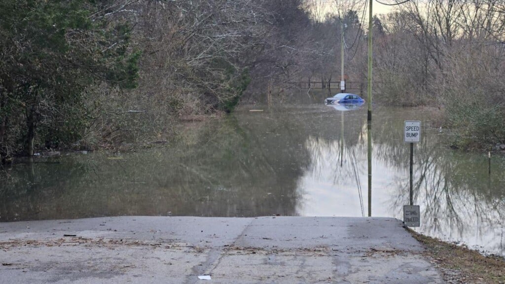
Officials say some reports state rainfall exceeded 6 inches in Warren County, resulting in significant flooding.
Current Roads Impacted, According to Officials
- Roads Considered Closed
- Fred Lively CLOSED
- Goodrum CLOSED
- HE Johnson between 252 & 353 CLOSED
- HE Johnson between Cosby Rd & Goshen Rd CLOSED
- Near 1296 Harry Cherry CLOSED
- Youngs Ferry CLOSED
- Weatherstone Subdivision CLOSED
- Matlock at 242 CLOSED
- Morris Duff CLOSED
- Dillard Rd on Nashville Rd side before Tracks CLOSED
- Belle Rive CLOSED
- Halls Chapel CLOSED
- Antioch Church CLOSED
- North Campbell at bridge from Goud Lake to Baker CLOSED
- Roads With Warning Cones or Barrels
in Place- Carter Sims
- 516 Dillard Rd
- Oakland Rd at Louisville Rd
- Oakland Rd near WR Helton
- 4199 Matlock
- 2137 Alvaton Greenhill
- 210 Morris Duff to Nashville Rd
- Seattle Slew
Repairs Underway
The Warren County Road Department and Bowling Green Street Department have been working to mark roads that have been covered by floodwater and are making emergency repairs to roads with flood damage.
According to emergency management, work on emergency repairs is underway to the access road of Weatherstone subdivision that will enable subdivision residents to enter and leave.
Water Rescues
Several vehicles also reportedly stalled when trying to drive into the subdivision through floodwaters. Emergency management says 13 water rescues have been conducted in a 24-hour period in Bowling Green and Warren County.
All individuals occupying those vehicle successfully reached safety, officials say.
Pearson stated, “Many of the water rescues that occurred were the results of drivers ignoring barricades and warning signs that had been placed to prevent drivers from entering flooded roadways. We urge drivers to “Turn Around – Don’t Drown” during this ongoing event.”
A Winter Storm Warning
The National Weather Service has issued a Winter Storm Warning starting at 6 p.m. Central Standard Time and continuing until 11 a.m. CST on Wednesday.
This may result in a dusting of snow overnight, officials say, which could result in slick roads Tuesday morning. Between 6 p.m. Tuesday and 11 a.m. Wednesday, 4 to 6 inches of snow is predicted to fall.
According to officials, snow is likely to accumulate quickly once it begins. This snow is expected to remain during a couple of days of chilling temperatures with overnight temperatures falling into single digits.
Wind chill during daylight hours will be in the single digits or could reach below zero. Travel should be limited.
Warming Shelters
A variety of emergency shelters and warming shelters will be available through Friday, according to emergency management.
Hotel, Inc. will be participating with other partners in providing a warming center Wednesday through Friday. The Salvation Army will also be operating a warming center. The Room in the Inn, along with the Salvation Army, will be providing emergency overnight shelter during the period. At the Salvation Army shelter, people will be taken in even when a bed may not be available as long as temperatures are at freezing or below.
Those needing shelter must be present by 8 p.m. CST.
In addition, 211 will be available to assist with information needed for shelter locations. Emergencies should still be directed to 911.